What is it

Individual trees measured from your point cloud

Clear Timber Analytics extracts individual trees and their measurements from LiDAR and other point-cloud data. Already have suitable data? Send it directly to our team. If not, we can source available third-party datasets or arrange new point-cloud collection worldwide through local partners. The result is a validated, GIS-ready tree inventory for use in urban forestry, surveying and infrastructure management.

What we work from

Mobile-mapping, aerial, UAV and handheld point clouds

We work with the LiDAR data collected by various capture method. Point density, coverage and accuracy differ a lot, but we tell you up front what each dataset can and cannot deliver.

drone

UAV LiDAR – mid scale sites, high detail

mobile mapping

Streets and roadside trees

aircraft

City-wide and regional coverage

handheld

Plots, parks and validation walks

backpack

Dense stands and closed canopy
Contact us and we will do the rest.

Supported data formats

.LAZ   .LAS   .COPC   .E57   .PLY

We do not require pre-classified or tiled point cloud, we’ll take care of that. We just need a raw pointcloud.

WHAT YOU GET

A tree inventory, not a point cloud

We hand over you a tree layer, with one record per tree, each with a crown geometry and a set of measurements.

Individual tree detection

Every tree is segmented as its own object with a unique number and a GPS position.

Stem points and crown polygons

We deliver two geometries per tree: a point at the stem base (location) and a polygon of the crown projection.

Height, DBH and crown measurements

The metrics come straight from the point-cloud geometry of each individual tree, not from a simplified model. So a crown is captured in its real shape, not simplified as a circle. It means the tree is read the way it actually stands.

Tree heightm
Diameter at breast height (DBH)cm
Crown diameter and projection aream · m²
Crown base heightm

Other available tree attributes

Beyond the core set, further attributes are agreed per project and delivered only where the data genuinely supports them:

  • Crown volume
  • Lowest limb height
  • Leaf area index (LAI)
  • Lean angle (inclination)
  • Clearance to road or rail
  • Distance to façade
  • Broadleaf/coniferous class
  • Change against a previous capture.

Before and After

From raw points to every tree seperate

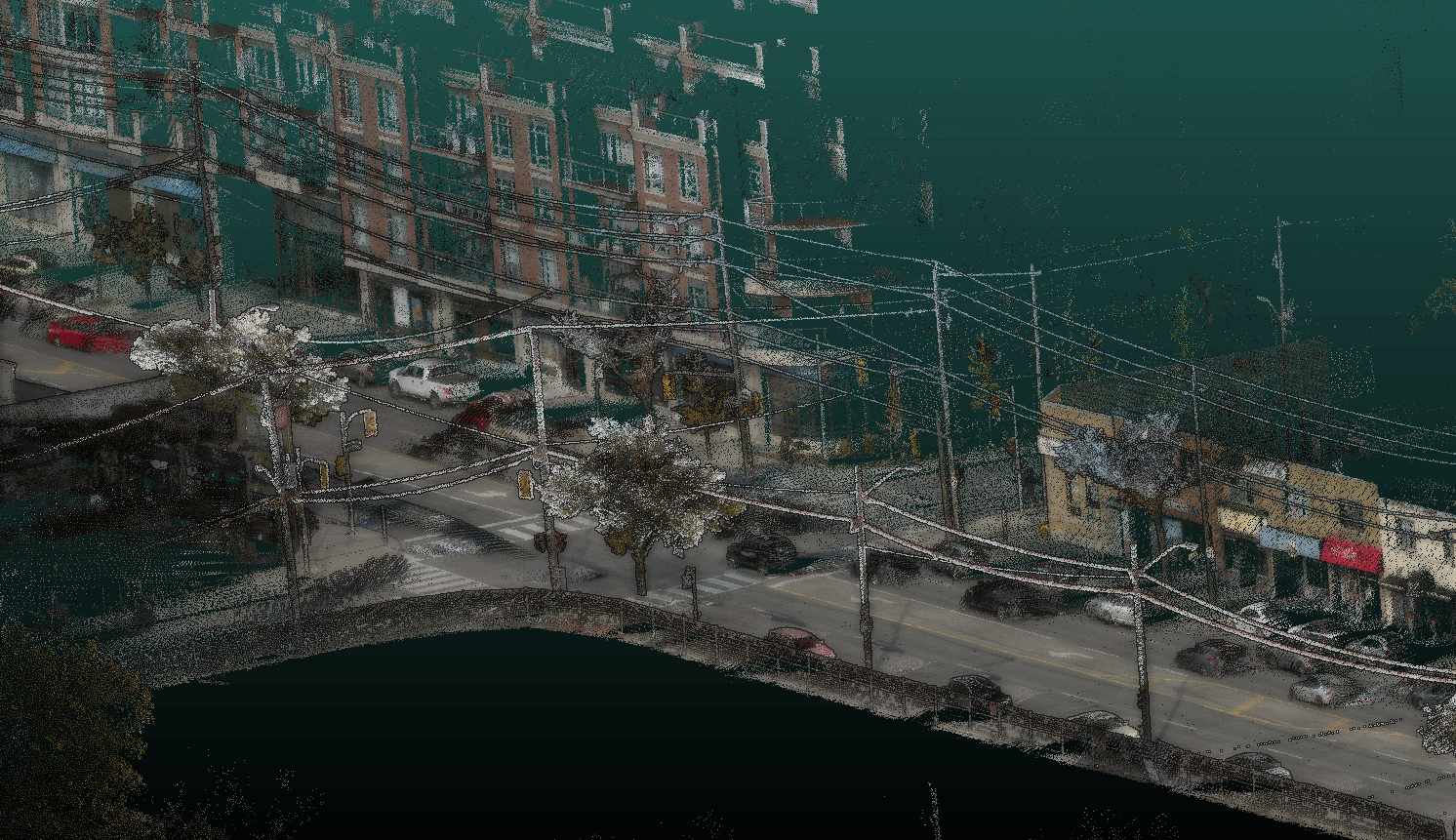
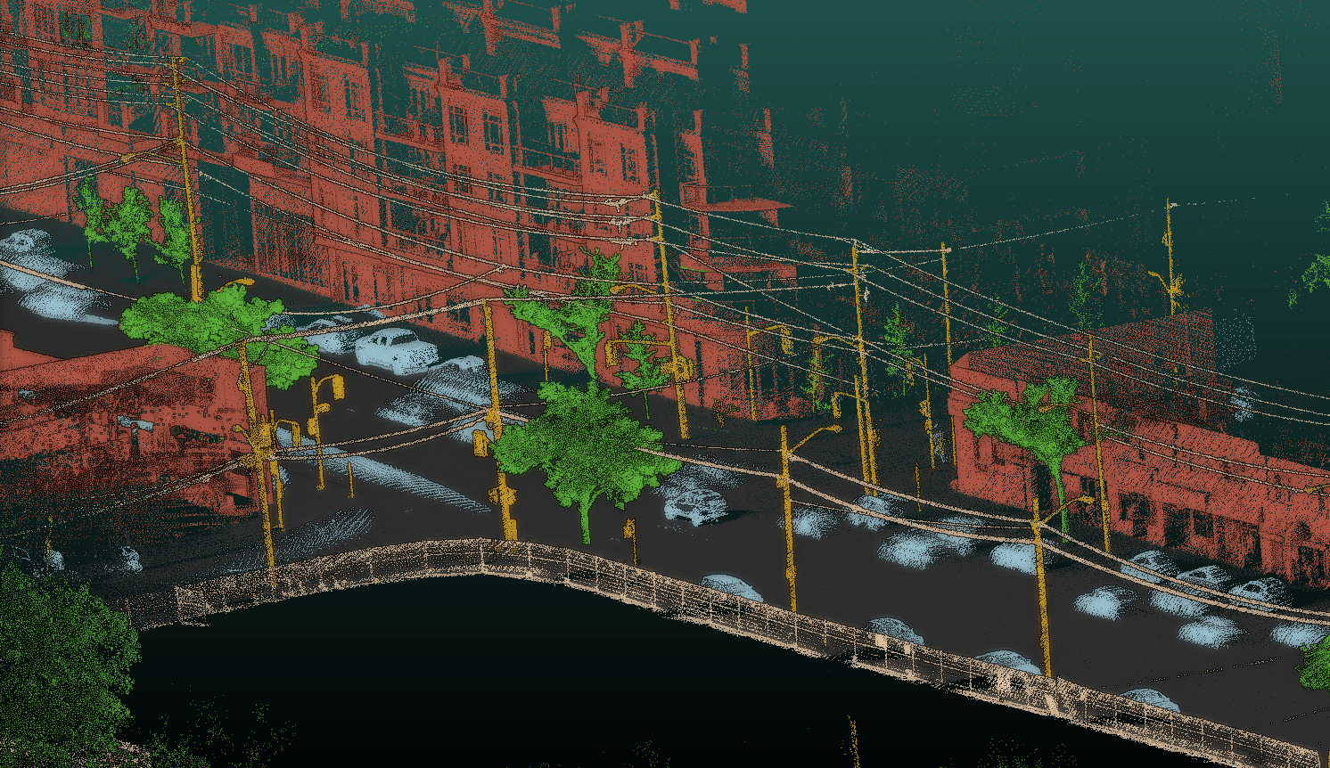
We turn raw, unclassified point clouds into a classified point clouds, where individual trees are identified and segmented separately.

Before After Point cloud before classification

How we get the data

Three routes to the same inventory

There are few ways to get the point cloud of your Area of Interest.

1 · ANALYSE YOUR DATA

Use the client's existing data

The client supplies previously collected point cloud data. It can be mobile-mapping, aerial, UAV or handheld. Clear Timber assesses its suitability and extracts the individual trees and requested measurements.

2 · SOURCE EXISTING DATA

Source suitable existing data

In many cases, the data already exists. When our mobile-mapping partners already cover the project area, Clear Timber identifies and purchases already existing data. 

3 · ARRANGE NEW COLLECTION

Arrange new data collection

If there is no suitable data is available, Clear Timber coordinates new point-cloud collection. We arrange it worldwide through qualified local partners and afterwards we run the analysis.

All three routes lead to the same result: a validated, GIS-ready tree inventory.

Methodology

Analysis and qc

STEP 1
Data intake and suitability check

Before the quote and processing we check the quality of the data. If the data cannot carry the attributes you asked for, we say so at this stage.

STEP 2
Classification and segmentation

Once the quality of collected data is validated, we classify the objects, extract a terrain model and segment all the trees.

STEP 3
Quality control

The segmentation of the trees is checked by our specialists.

STEP 4
Tree metrics

When the tree segmentation is checked and confirmed we can run the measurements. Each tree gets the list of measured attributes, such as DBH, tree height and crown parameters.

STEP 5
Final validation

Before the handover of the results, our specialists check again the outcome. We check outliers, unrealistic height-to-DBH ratios and remove the metrics of low-confidence trees.

STEP 6
Delivery

Once the results are reviewed, the inventory in form of zipped package is delivered to the client.

Honest Limitations

What point clouds cannot tell you


  • Data quality depends on the scanner type and method used, as well as the terrain itself. Areas with dense low vegetation can reduce point-cloud accuracy and result in missing measurements.

  • DBH is measured only when sufficient data is available. If a stem is covered by shrubs or other obstacles, such as fence or a car, the measurement cannot be calculated.

  • If a tree is located far from the scanning path or is captured from only one side, there might not be enough points to calculate reliable metrics. As a result, the data for that specific tree may be incomplete or less accurate. 

  • Vitality and health status usually require additional data sources, such as multispectral imagery or field verification.
 

Delivery

GIS-ready delivery formats

We deliver structured tree data in GIS-ready formats compatible with your existing systems.
Vector
GeoPackage (.gpkg)
Shapefile (.shp)
GeoJSON
DXF / DWG
Tables and databases

CSV / XLSX with coordinates

WHAT’S BEHIND

See what you get →

Start here

FILL IN THE FORM

If you happen to have already your data, send it to us a small area and we return with a short assessment of what your data can deliver. If you have no data yet, tell us the project area instead.

Where are you starting from?

Which best describes your situation?
Name
Site location, approximate area or tree count, what kind of tree parameters you need and any data you already have (let us know what's the file extension and how it was captured).